STSORBIT PLUS, usually known as STSPLUS, is intended for use during Space Shuttle missions and for general satellite tracking using NASA/NORAD 2-Line Orbital Elements. One primary satellite and up to 32 additional "static" or "real time" satellites may be simultaneously tracked in real time on most computers. Both orthographic and rectangular VGA color map projections are available, displaying the Earth as a globe or the more traditional "flat map". A new "Night Vision" mode shows the maps in RED to protect the user's night vision, great for color laptops! Tabular line-of-sight satellite pass predictions may be made from within STSORBIT PLUS and passes of interest may be easily displayed. STSPLUS is widely used throughout NASA and USAF as well as by thousands of "just plain folks" worldwide. STSPLUS was seen operating on the Russian Mir Space Station on NASA Television during the STS-86 mission on 02 October 1997.
STSORBIT PLUS is very accurate when used with current (and accurate) 2-Line Elements (TLEs). The program has been qualified by the USAF and meets the requirement of placing a satellite within 0.5 km over a 24-hour time span from the epoch time of the 2-Line Elements. It is used daily at the USAF Central Computer Complex at Cape Canaveral, by the DOD C-Band Radar Network at their worldwide radar sites, and at half a dozen NASA and aerospace control centers around the country. The program is made available to schools through the NASA Spacelink BBS and the NASA Teacher Resource Centers. Numerous schools and amateur radio enthusiasts have made contact with the space shuttle via SAREX amateur radio while using STSORBIT PLUS.
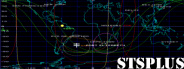
STSPLUS is intended to display the position and ground track of an orbiting satellite on a selection of maps ranging from a full map of the world to zoom maps showing considerable detail. The program has special features implemented at the request of NASA astronauts and others for use during a NASA Space Shuttle mission. With the appropriate 2-line elements, STSPLUS displays the position and ground track of a variety of satellites such as the Space Shuttle, the Hubble Space Telescope, the Gamma Ray Observatory, or the Russian MIR Space Station. Accurate TDRS coverage, including times for acquisition and loss of signal, is calculated for satellites which use that satellite network for communications. Special Location and Tracking Station displays show concentric isocontours, circles of equal satellite altitude; these special maps can be especially valuable for visual or amateur radio sightings.
STSPLUS displays a portion of the Earth using either an orthographic projection (the Earth seen as a globe) or cylindrical projection (similar to the Mercator projection commonly used). The maps show most of the Earth's land boundaries and continental areas. Major oceans, seas, and rivers are easily recognizable. Considerable detail is shown at higher zoom factors. Automatic map generation ensures that the satellite is always displayed. The display shows the selected satellite as a small symbol or icon, the projected orbital ground track for the next three hours and the past one and a half hours, and many other features including circles of visibility, TDRS coverage, and the solar terminator. Additional higher detail Map Database Files are available with registration.
- Genre: Tool
- Platform: MS-DOS
- Website: celestrak.com/software/dransom/stsplus.html